Mount Ulriken, Haukelandsbakken 40, 5009 Bergen, Norway
What travelers say:
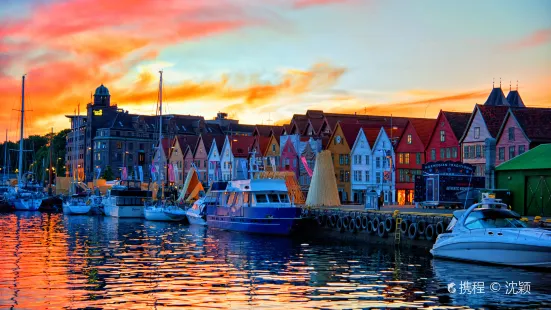
Norway | Bergen Two Mountains Cityhike Route and Description
🚗Route
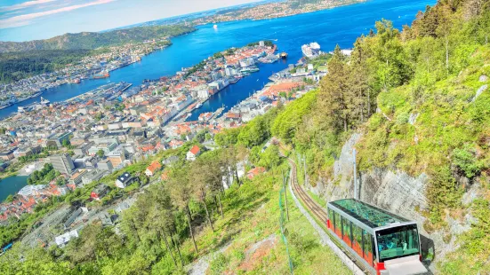
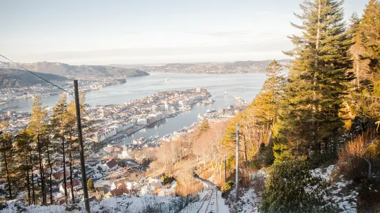
1. You can hike/take the cable car up and down Fløyen Mountain from the city.
2. You can hike/take the shuttle bus from the city to Ulriken, and you can hike/take the cable car.
3. The roads on the two mountains are connected, and the official data is 13 kilometers.
4. The route to the top of Ulriken is mainly a loop. If you have enough time and energy, you can walk directly to F.
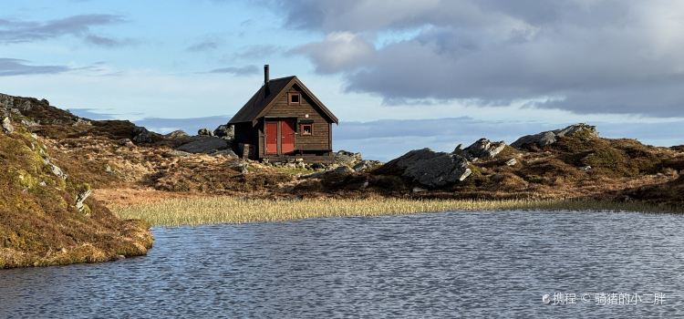
🚗The scenery on the trail at the top of the mountain is still good, and it can even be said to be unexpected. There are many small lakes on the mountain, which feels a bit sad. Basically, there is water, mud, grass, and big rocks. In many places, you have to cross the river by stepping on stones. Hiking on the top of the mountain is not tiring, and there are fewer climbs, but you must pay attention to anti-slip (muddy roads) and stepping on empty (there is water below).
🚗Others
1. There is only business at the cable car station on the mountain, and there is a restaurant open, so it is best to bring a water bottle and energy supplements.
2. There are arrows or stone piles on the hiking route to indicate the direction, but the scenery on the top of the mountain is very repetitive, so be careful if you have a poor sense of direction.
3. The weather in Norway is changeable. It rains almost every day, and it even rains on sunny days, so it is best to wear waterproof clothes. The days are longer in summer, and it was still bright when I came down at almost 9 o'clock.
4. There are many bright and dark puddles on the top of the mountain, so it is recommended to wear hiking shoes or waterproof off-road shoes.
More
Reviews of SKYSKRAPEREN RESTAURANT
Some reviews may have been translated by Google Translate


Norway | two mountain cityhike route and description 🚗 route 1. From the city can walk/cable car down Flyen mountain. 2. From the city can walk/shuttle bus to Ulriken, you can walk/cable car. 3. The roads on the two mountains are connected, and the official data is 13 kilometers. 4. The Ulriken Peak Route is mainly a ring road. If you have enough time, you can go directly to F. 🚗 The scenery on the Peak Trail Road is still OK, and it can even be said that it is very unexpected. There are many small lakes on the mountain, which is a bit sad. Basically, it is water, mud, grass, big stones, and many places are stepping on stones to cross the river. The top of the mountain is not tired, and there are fewer climbs, but you must pay attention to non-slip (mudy road) and stepping on the air (all below are water). 🚗 Other 1. Only the cable car station on the mountain has a business, there is a restaurant open, so it is best to bring a water cup and energy supplement. 2. The hiking route has arrows or stone piles indicating the direction, but the mountaintop route scenery is very repeated, and the direction is poor. 3. The weather in Norway is changeable, it rains almost every day, even sunny days, so it is best to wear waterproof clothes. The summer day is longer, and it is still very bright when I come down at 9 o'clock. 4. There are many bright and dark puddles on the top of the mountain. It is recommended to wear hiking shoes or waterproof off-road shoes.
🚗 Route 1. From the city, you can walk/cable car down Flyen Mountain. 2. From the city, you can walk/shuttle to Ulriken, you can walk/cable car. 3. The roads on the two mountains are connected, and the official data is 13 kilometers. 4. The Ulriken Peak Route is mainly a ring road. If you have enough time, you can go directly to F. 🚗 Today's hiking route 1. The old city -montana hostel is about 4km. The Ulriken cable car station is basically flat, and there is a slope at the last point. 2. hostel-Ulriken- Peak Cable Car Station, this section is 2km, the front slope is up the mountain road, and the back 1km is full of steps with large stones. This section is the most difficult, and you can also go around the slope stone road next to it, 3km.
🚗 Route 1. From the city, you can walk/cable car down Flyen Mountain. 2. From the city, you can walk/shuttle to Ulriken, you can walk/cable car. 3. The roads on the two mountains are connected, and the official data is 13 kilometers. 4. The Ulriken Peak Route is mainly a ring road. If you have enough time, you can go directly to F. 🚗 Today's hiking route 1. The old city -montana hostel is about 4km. The Ulriken cable car station is basically flat, and there is a slope at the last point. 2. hostel-Ulriken- Peak Cable Car Station, this section is 2km, the front slope is up the mountain road, and the back 1km is full of steps with large stones. This section is the most difficult, you can also go around the slope stone road next to it, 3km. After going up, you can sightseeing, and there is a restaurant at the Peak Cable Car Station where you can eat and drink coffee. 3. After going up the mountain, I was going to take a loop on the way, but I met a few local girls and walked along the road to Floyen together, because I lived on Uri's side and turned back at 6:30. 🚗 The scenery on the mountaintop trail road is still possible, and it can even be said that it is very unexpected. There are many small lakes on the mountain, which is a bit sad. Basically, it is water, mud, grass, big stones, and many places are stepping on stones to cross the river. The mountain top is not tired, there are fewer climbs, but you must pay attention to non-slip (muddy road) and stepping on the air (all water below). 🚗 Other 1. There is only a commercial cable car station on the mountain, and there is a restaurant open, so it is best to bring a water cup and energy supplement by yourself. 2. The hiking route has arrows or stone piles indicating the direction, but the mountaintop route is very repetitive and the direction is poor. 3. The weather in Norway is changeable, it rains almost every day, even on sunny days, so it is best to wear waterproof clothes. The day is longer in summer, and it is still very bright when I come down at 9 o'clock. 4. There are many bright and dark puddles on the top of the mountain. It is recommended to wear hiking shoes or waterproof off-road shoes.